projects
Inner Block House
The apartment on the canal
Office Building
Urban village in Tokyo
Housing TransformationsFamily Loft
Secret Garden
Ministerie van Maak
Transform&extend
Micro-House
The hotel
Villa Veenmmol
Villa Minerva
Watchtower Zaanse
Story from the woods
Book art fair
School yard Rotterdam
competitions
Tili Wine Italy Guest home
Europan 16
Sminchov City
Ethiopian Satellite Preschool
Castel resort. Italy
Smart Harbor. Italy
Space of Culture.
Children park. Kazan
Social housing Westerlo
Extension A.Alto museum 1
Extension A.Alto museum2
Two museums. Budapest
Social housing. Greece
“up to 35”. Greece
about us / contact
projects
Secrer Garden
Family Loft
Ministerie van Maak
Transform&extend
Micro-House
The hotel
Tiny house Rotterdam
Vila Veenmmol
Watchtower Zaanse
Story from the woods
Book art fair
Family house in Weesp
School yard Rotterdam
competitions
Sminchov City
Castel resort
Smart Harbor
Space of Culture
Children park Kazan
Social housing Westerlo
Extention A.Alto musium 1
Extention A.Alto musium2
Two museums ,Budapest
Social housing,Greece
about us
Ioannis Aggelakos
Eirini Xanthopoulou
Ekaterina Mirizaki

THE MUSEUM COMPLEX AS A LANDSCAPE AND TOWNSCAPE CATALYST
Regarding both the question of the proper general location to be chosen for the MPH complex and, more precisely, that of its appropriate spatial arrangement (masses, voids, prevailing geometry, circulation and accesses, relation to the topography, heights), it occurs that, within the context of the above stated conditions :
The building should be situated as far as possible from the Zamek Ujazdowski and Os Stanislawowska. This means that the building is located in its entirety north of the Trasa tunnel, occupying a trapezium-shaped terrain limited by the Trasa, ul. Jazdow, the northern border of the area designated for the MPH and the slope of the Skarpa.
The complex should adopt, as the immediately recognizable trait of its structure, organization, form and modus operandi with its surroundings, a pure and plainly stated geometrical regulatory background, i.e. a grid-like rectangular organization, so as to combine smoothly and tightly with the prevailing -and mutually crossing at a right angle- directions of both the park and the axis.
Both these statements would help decisively the MPH building respond to its landscape (park) and townscape (axis) surroundings, as well as to get actively involved in the process of their spatial intermingling, as stated . It becomes clear that, as a result, no remnant of the oblique and upsetting Trasa direction will be any more perceivable on the plateau topping the tunnel, apart from the characteristic line of trees (at the edge of the southern bank of the Trasa). It will be explained how this oblique alley (and its pathway) shall play a considerable formative role in the composition of the new plateau and the axis.
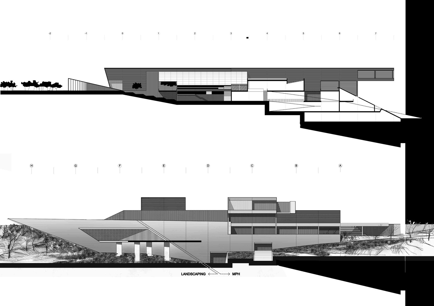
THE MPH SPATIAL ARRANGEMENT
The main environmental challenges to be met being: To embed the project evenly on to the two elements of the Skarpa, i.e., the plateau on its top (c.a. +29,50) and its slope (approximate inclination 1 / 4 north of the Trasa);
To condition the thorough merging and interaction of the building complex with the park;
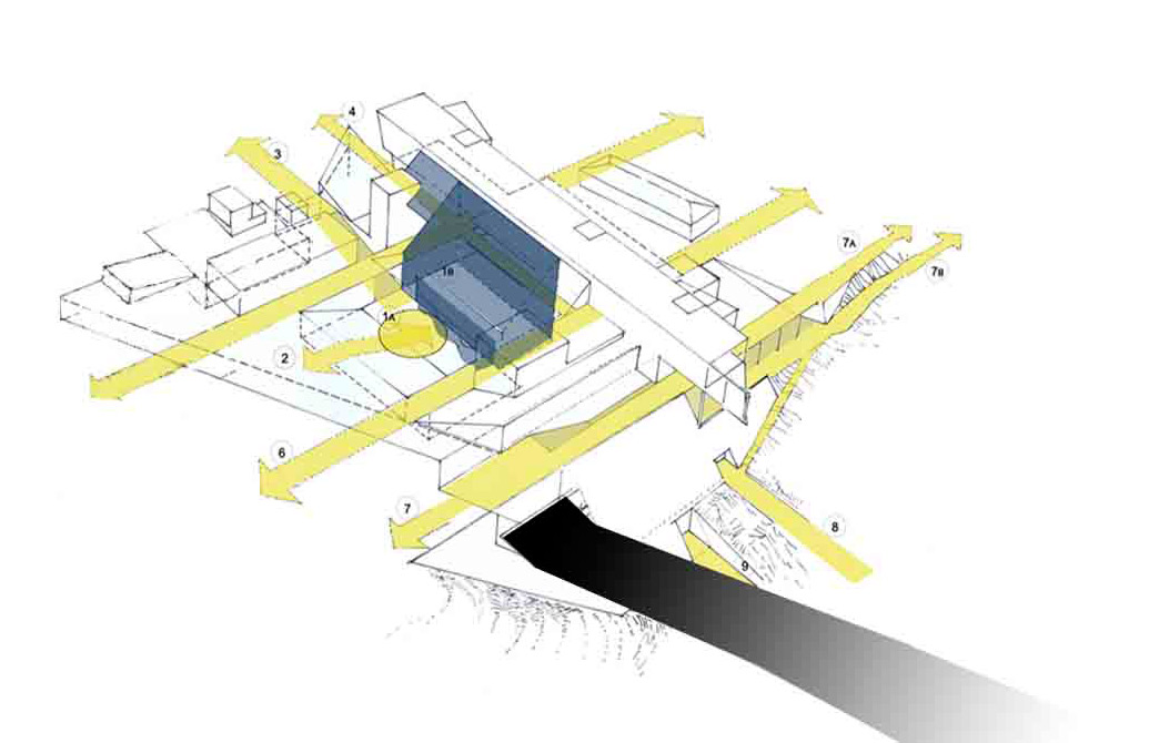
To make the MPH complex function as a generator of multiple flows in terms of movement and view; flows directed -in response to the rectangular grid - both N-S and E-W; flows which should penetrate the building mass and allow for the smooth and tight connection - both kinetic and perceptual- of the existing street and path network of the Jazdow area north of the museum site, to the new plateau of the Os Stanislawowska and the Zamek Ujazdowski southwards.
The proposed solution: Produces a rich and vivid spatial network, wherein, spacious planted courtyards, built forms, pedestrian routes and piazzas co-act so as to verify the proper modus operandi by which the MPH should address itself to the park.
This spatial network is posed on the Skarpa plateau and shelters the main bulk of the MPH programme, distributed in three levels (+25,00 containing the main court and entrance, the public zone and a great part of the permanent exhibitions zone; +30,50, at the ground level of the park, contains pedestrian routes running through the building, upward extensions of the public zone, the temporary exhibition zone and supplementary functions; lastly, + 36,00 contains the Education and Seminar zone and the Restaurant area). As a result, the built masses standing above the park level are markedly reduced. Dominant among these is the lightweight and transparent construction of the Forum roof, marking the heart of the complex, a luminous sign of it in the evening. It rises up to the imposing bar of level +36,00, at the eastern edge of which the restaurant projects audaciously over the slope, overlooking the entire panorama of the Wisła river, the Skarpa and the Zamek Ujazdowski.
Eastwards, at the proximity of the embankment edge, the spatial network gives way to an artificial slope: A tilted surface, half-façade and half-roof, forms the eastern end of the complex and serves multiply:
It reorganizes (inclination 1 / 2) the sliding and smooth slope north of the Trasa and, hence, homogenizes it with its southern counterpart in front of the Zamek Ujazdowski. In such a manner a proper conclusion is effected, on the one hand, concerning the symbiosis of the MPH with the topography and, on the other, as regards the restitution of the unity not only of the park but also of the fragmented slope of the Skarpa.
It shelters the deeper part of the permanent exhibition zone (level +19,50), the Research, Academic and Administration zone (levels +25,00 and +19,50), the Technical Utilities zone and the Storerooms and Garages (both at level +14,00). It receives and regulates the course of Aleja na Skarpie which, originating from the existing park pathways to the north, creeps evenly into the MPH structure and becomes incorporated into its spatial arrangement, as one of its indismissible features.
Finally, it composes the structural, spatial and landscape context in which to set the eastern entrance of the Trasa tunnel.
PARKING FACILITIES – THE FOOT OF THE SKARPA
Coaches are arranged under the fly-over of the Trasa. Car parks, alike, are organized in the vicinity of Myśliwiecka, at the foot of the slope.
An optical barrier similar to the one mentioned in 6.3 is placed along the southern base of the fly- over. It serves as a protective filter of the lengthy Baroque landscaping and piazza extending to the south and marking the lower part of Oś Stanislawowska, against the alien milieu of the coach parking areas. It also serves as a recreation spot.
A small open-air ampitheatre is placed near the Agrykola round-about, as one more discrete element with which to enrich the serene atmosphere prevailing at the foot of the Skarpa, across the Zamek Ujazdowski.